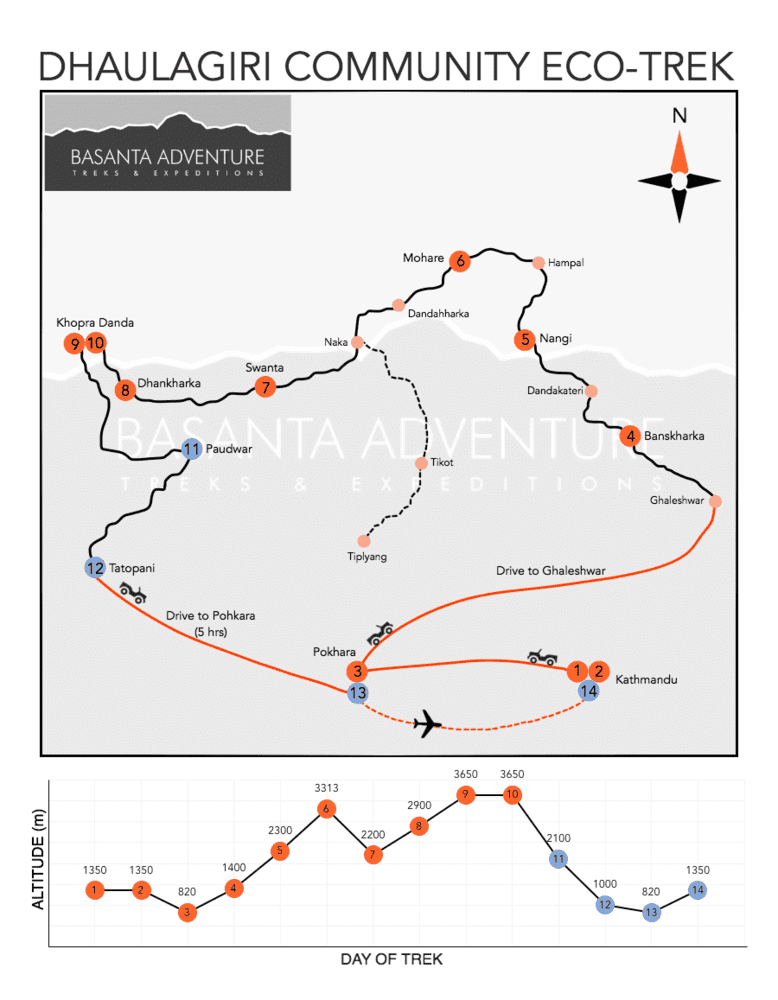
The 15-day Dhaulagiri Community Eco Trek is an off-the-beaten-path journey through community-run villages, rhododendron forests, Mohare Danda, Swanta, Khopra Ridge, and sacred Khayer Lake. Combining close views of Dhaulagiri and Annapurna with locally managed lodges and village projects, the trek offers a quieter Himalayan experience where tourism directly supports schools, livelihoods, and conservation initiatives in rural Myagdi mountain communities today.
Overview of Dhaulagiri Community Eco Trek
The 15-day Dhaulagiri Community Eco Trek is one of the most distinctive community-based trekking journeys in western Nepal. The route combines Mohare Danda, Khopra Ridge, traditional Magar villages, community lodges, extensive rhododendron forests, and an optional high-altitude excursion to Khayer Lake.
Unlike many popular trekking routes where tourism infrastructure has developed around privately operated lodges, much of this trail was created around a community tourism model.
Local villages participate directly in operating accommodation, managing trekking services, supporting community projects, and keeping a larger share of tourism income within the region.
This gives the Dhaulagiri Community Eco Trek a very different character from conventional trekking in Nepal.
The mountains are impressive, but they are only one part of the journey.
You also walk through villages where schools, agriculture, local enterprises, community forests, homestays, and tourism projects are closely connected.
The trek begins in Kathmandu before traveling west to Pokhara, Nepal's famous lakeside city and the main gateway to the Annapurna region.
From Pokhara, we continue by road toward Galeshwor in Myagdi District.
Galeshwor lies near Beni and the Kali Gandaki corridor, approximately 75 to 80 km by road from Pokhara depending on the exact route used.
The walking section begins from this lower subtropical landscape.
Our first destination is Banskharka at approximately 1,525 m.
The trail climbs through terraced farmland, forest, and rural settlements, immediately leaving the busier road corridor behind.
Banskharka is particularly known for agriculture and orange cultivation.
Instead of staying in a large commercial trekking lodge, the community-based accommodation introduces you to the philosophy of the trail from the beginning.
The following day, we continue toward Nangi at approximately 2,300 m.
Nangi is one of the most important cultural stops on the Dhaulagiri Community Eco Trek.
The village became widely known through the work of Mahabir Pun and community initiatives involving education, rural technology, local enterprises, and sustainable development.
Trekkers may have opportunities to learn about community projects, local schools, agriculture, handmade paper production, medicinal plants, or other village activities depending on what is operating during the visit.
The purpose is not to turn the village into an attraction.
It is to understand how tourism fits into a much larger local economy and community structure.
From Nangi, the trail climbs more strongly toward Mohare Danda.
The approximately 1,000 m elevation gain makes this one of the more energetic walking days of the trek.
Much of the route passes through oak and rhododendron forest.
During spring, particularly from late March through April, the forest can become one of the most colorful sections of the journey as Nepal's rhododendrons flower along the ridge.
The forest gradually opens as we approach Mohare Danda at approximately 3,313 m.
This isolated ridge is one of the finest viewpoints on the trek.
On a clear day, the Himalayan skyline stretches across Dhaulagiri I, Tukuche Peak, Nilgiri, Annapurna South, Machhapuchhre, and numerous surrounding summits.
Sunrise and sunset are particularly impressive.
Unlike Poon Hill, which is one of Nepal's busiest sunrise viewpoints, Mohare Danda normally receives far fewer visitors.
The atmosphere is quieter, and the community lodge sits directly on the ridge, allowing trekkers to experience both sunset and sunrise without rushing.
After Mohare Danda, the trail turns toward Swanta.
The landscape changes significantly during the descent.
High ridge terrain gives way to thick rhododendron and oak forests before cultivated slopes and village farmland reappear.
Swanta sits at approximately 2,200 m and is another traditional Magar settlement along the community trail.
The descent gives the legs a break after the climb to Mohare, but it also prepares us for another significant rise.
From Swanta, we climb toward Dhan Kharka, also known as Chistibung, at approximately 3,020 m.
The trail leaves the village environment and enters increasingly quiet forest.
This part of the Dhaulagiri Community Eco Trek overlaps with the lesser-traveled approach toward Khopra Ridge.
Oak and rhododendron forest surrounds much of the path.
Seasonal grazing areas appear at higher elevations, and mountain views become broader as we move toward the tree line.
From Dhan Kharka, we continue to Khopra Danda at approximately 3,660 m.
The walking distance is relatively short, but the trail gains more than 600 m.
The final climb opens onto one of the most dramatic ridges of the southern Annapurna landscape.
Dhaulagiri I at 8,167 m rises across the Kali Gandaki Valley while Annapurna South, Nilgiri, Baraha Shikhar, and several neighboring peaks appear remarkably close.
The Kali Gandaki corridor lies far below.
Khopra Danda is often described as an alternative to the busier viewpoints around Ghorepani, but it offers a very different mountain perspective.
The ridge sits closer to Dhaulagiri and provides a striking view across one of Nepal's deepest mountain valleys.
For trekkers who want the full adventure, the following day offers an optional excursion to Khayer Lake.
Khayer Lake, sometimes written Khair Lake or Kaire Lake in older trekking itineraries, lies at approximately 4,600 to 4,660 m.
This is the highest point of the Dhaulagiri Community Eco Trek.
The round trip from Khopra Danda is long and physically demanding.
Trekkers should expect approximately 14 to 16 km of walking and around 9 to 11 hours on the trail depending on pace, weather, and trail conditions.
The route climbs through increasingly open alpine terrain.
Vegetation disappears as the path enters rocky slopes beneath the high Annapurna landscape.
Snow may remain on sections of the route during early spring, late autumn, or after recent storms.
Khayer Lake has religious importance for local Hindu communities and becomes a pilgrimage destination during the Janai Purnima period.
For trekkers, reaching the lake provides both a cultural experience and the greatest physical challenge of the journey.
The excursion is optional for a reason.
Trekkers who are tired, experiencing symptoms of altitude problems, or simply prefer a more relaxed day can remain around Khopra Danda and enjoy the ridge views.
There is no benefit in forcing the Khayer Lake hike if conditions or personal fitness make the day unsuitable.
After Khopra, the journey begins a dramatic descent toward Paudwar.
The route drops by well over 1,500 m through grassy slopes, stone steps, rhododendron forest, and agricultural terraces.
Paudwar sits at roughly 1,900 to 2,000 m, although local sources and older itineraries record slightly different elevations depending on the exact point used in the village.
It is a substantial Magar settlement and one of the most interesting cultural stops near the end of the trek.
Community activities in and around Paudwar include agriculture and locally managed enterprises.
The village provides a completely different atmosphere from the exposed ridge at Khopra.
Temperatures become warmer, vegetation becomes dense again, and daily village life returns to the trail.
The final walking stage continues downhill toward Tatopani at approximately 1,190 m.
Tatopani means "hot water" in Nepali and is known for its natural hot springs beside the Kali Gandaki River.
After several days of climbing and descending across the community eco trail, soaking in the warm mineral water provides a particularly satisfying end to the trekking section.
From Tatopani, we drive approximately 95 to 100 km back toward Pokhara.
Road conditions and construction can significantly influence driving time, so the journey normally takes around 4 to 5 hours or longer when traffic or road work is heavy.
A short flight from Pokhara returns us to Kathmandu the following day.
The Dhaulagiri Community Eco Trek is considered a moderate trek overall.
Most walking days involve approximately four to seven hours on the trail.
There is no technical climbing, glacier crossing, or high mountain pass.
However, the trek should not be considered effortless.
The trail includes repeated climbs and descents, substantial elevation gain between Nangi and Mohare Danda, another long climb between Swanta and Khopra, and an optional excursion above 4,600 m.
Trekkers should have reasonable cardiovascular fitness and be comfortable walking on stone steps, forest paths, uneven mountain trails, agricultural tracks, and steep descents.
The Khayer Lake excursion demands considerably greater endurance than the rest of the itinerary.
For travelers seeking an off-the-beaten-path trek in the Annapurna and Dhaulagiri region, the greatest advantage is variety.
One journey combines subtropical farmland, traditional villages, community projects, rhododendron forest, Himalayan ridges, mountain panoramas, high-altitude terrain, sacred Khayer Lake, the Kali Gandaki Valley, and natural hot springs.
More importantly, the community tourism model gives the trek a purpose beyond simply reaching a viewpoint.
Best Time for the Dhaulagiri Community Eco Trek
The best time for the Dhaulagiri Community Eco Trek is during spring from March to May and autumn from late September through November.
Spring is particularly attractive for this route because large sections between Nangi, Mohare Danda, Swanta, and Dhan Kharka pass through rhododendron forest.
March begins cooler, especially on Mohare and Khopra, while April normally brings comfortable daytime temperatures and extensive rhododendron flowering.
May remains suitable, although afternoon cloud becomes more common as the summer monsoon approaches.
Autumn offers excellent mountain visibility.
After the monsoon clears dust and moisture from the atmosphere, October often provides stable weather, dry trails, and sharp views of Dhaulagiri and the Annapurna range.
November remains an excellent trekking month but becomes colder at Mohare Danda, Dhan Kharka, and Khopra Ridge.
The summer monsoon from June through August is less suitable because heavy rainfall can make forest trails muddy and slippery.
Clouds may also obscure mountain views.
Winter trekking is possible on the lower community trail, but snow and cold can make Khopra Ridge and the optional Khayer Lake excursion significantly more difficult.
Permits Required for the Dhaulagiri Community Eco Trek
The Dhaulagiri Community Eco Trek enters the wider Annapurna trekking region and includes Khopra Ridge, so trekkers require an Annapurna Conservation Area Permit, commonly known as ACAP.
The current Nepal trekking regulations also list the Khopra Trek among routes where a TIMS Card and licensed trekking guide are required.
Permit rules can change, so Basanta Adventure confirms the applicable documentation before departure and arranges the required trekking permits through the appropriate authorities.
No technical climbing permit or restricted-area permit is required for the standard Dhaulagiri Community Eco Trek.
The optional Khayer Lake excursion remains a trekking activity and does not require a mountaineering permit.
Why Choose Basanta Adventure for the Dhaulagiri Community Eco Trek?
Basanta Adventure has been organizing Himalayan journeys since 1998.
Over more than two decades, our team has led trekking, touring, and expedition programs across Nepal, Tibet, and Bhutan while developing extensive experience in the practical realities of Himalayan travel.
Our long history leading treks through the Annapurna region is particularly valuable on the Dhaulagiri Community Eco Trek.
The Annapurna region contains everything from busy teahouse trails to remote community routes.
Operating successfully here requires much more than knowing the destination names.
Guides need to understand trail conditions, local transport, weather patterns, accommodation limitations, seasonal changes, cultural expectations, and how quickly conditions can vary between the lower Kali Gandaki Valley and ridges above 3,500 m.
Our team has spent decades working with these conditions.
That experience helps us design realistic daily walking schedules rather than simply placing destinations on an itinerary.
The Dhaulagiri Community Eco Trek also requires smooth and dependable logistics.
The journey combines hotels in Kathmandu and Pokhara, road transportation to Galeshwor, community lodges, village homestays, mountain accommodation, permit management, guides, porter support, transportation from Tatopani, and a domestic flight from Pokhara.
Many of these services operate in areas where last-minute alternatives may be limited.
Our operations team coordinates these details before the trek begins.
Transport needs to arrive at the correct trailhead.
Community accommodation needs to be confirmed.
Porters and guides need accurate schedules.
Permits need to be ready before entering controlled trekking areas.
The return vehicle from Tatopani must also take current road conditions into account.
Good logistics do not make the mountains predictable.
They make the parts we can control dependable.
This becomes especially useful when road construction, weather, accommodation changes, or local conditions require an adjustment.
Rather than treating the itinerary as a rigid timetable, our guides and operations staff work together to keep the journey smooth while responding to what is happening on the ground.
Our experience leading treks through the Annapurna region also helps with safety and pacing.
The trek remains moderate for most days, but elevation changes should not be underestimated.
Nangi to Mohare Danda involves a significant climb.
Swanta to Dhan Kharka and Khopra requires another major gain.
The optional Khayer Lake excursion rises above 4,600 m and can take almost the entire day.
Our guides maintain a sensible pace, monitor how trekkers respond to increasing altitude, encourage proper hydration, and make practical decisions about whether the optional high-altitude excursion is appropriate.
The objective is not to rush through the route.
It is to complete it comfortably while having enough time to enjoy the communities and landscapes that make the trek special.
Basanta Adventure is an ISO 9001:2015 certified company.
Our ISO certification reflects our commitment to quality management, professional trip organization, service consistency, and reliable operating procedures.
Basanta Adventure first achieved ISO 9001 certification in 2011 and later upgraded to the ISO 9001:2015 standard.
The company has also received recognition from Travelife for its commitment to sustainable tourism.
Sustainability is particularly relevant on the Dhaulagiri Community Eco Trek because the philosophy behind the route closely matches our own approach to responsible travel.
Community tourism works best when visitors contribute positively to the places they visit.
Using locally managed accommodation helps keep tourism revenue within rural villages.
Local guides, porters, drivers, lodge staff, farmers, and suppliers all benefit when trekking services are purchased locally.
At the same time, visitors need to minimize unnecessary environmental pressure.
Basanta Adventure follows sustainable trekking policies that encourage responsible waste management, careful use of water and energy, respect for wildlife, appropriate behavior in villages, support for local communities, and reducing avoidable environmental impacts.
Our guides also encourage trekkers to carry reusable water bottles and purification systems rather than depending entirely on disposable plastic bottles.
This approach is particularly suitable for a trail designed around community development and low-impact tourism.
Beyond Nepal, Basanta Adventure is also one of the long-established Himalayan operators specializing in Tibet tours and expeditions.
Our Tibet operations date back to 1998 and have provided our team with extensive experience managing journeys across remote and high-altitude landscapes.
Organizing travel in Tibet requires detailed planning, reliable transportation, permit management, experienced local staff, contingency planning, and an understanding of how altitude and remote geography affect travelers.
Those operational skills carry directly into the way we manage trekking journeys in Nepal.
For the Dhaulagiri Community Eco Trek, we combine decades of Himalayan experience with a route whose central purpose is community benefit.
The result is not simply another mountain trek.
It is a carefully organized journey through rural Nepal where the landscapes, local people, and tourism model are equally important parts of the experience.
What is included in the tour
Kathmandu Portion:
- 3 nights in Hotel Manaslu or similar hotels on BB basis as per the itinerary in Kathmandu
- Half day guided sightseeing tour of Kathmandu
- 1 professional English-speaking guide
- Private transportation during sightseeing
Pokhara Portion:
- 2 nights’ accommodation in a twin sharing room with bed and breakfast in a hotel
Transportation:
- Private vehicle to and from the trek initiation point.
- Kathmandu – Pokhara by private vehicle.
- All the necessary airport transfers as per the itinerary
- Air fare: Pokhara – Kathmandu
Trek Portion:
- Twin sharing accommodation as per the itinerary in lodge en-route
- ACAP National park fee
- TIMS Card
- Professional licensed holder Trekking guide
- Assistant Guides as per number of clients
- Necessary Porters (weight max. 12 kg per clients)
- Insurance for Nepali staffs
- Necessary equipment for trekking staff
- Guide and porter daily allowance
- Emergency medical kit box
- Trekking kit bag
What is NOT included in the tour
- Nepal Visa fee
- Any meals (Breakfast, Lunch, Dinner and Tea/Coffee) during trek
- Travel insurance (must cover expenses of rescue service including helicopter)
- Personal Gears: (all trekking gears are easily available on rent and to buy in Kathmandu)
- Lunch and dinner in Kathmandu and Pokhara
- Liquor beverages (soft and hard drinks)
- Expenses of personal nature e.g. laundry, phone call etc.
- Gratuity for staff
- Expenses incurred due to unforeseen circumstances
- Services not mentioned here
- Watch sunrise and sunset from Mohare Danda at approximately 3,313 m/10,869 ft with sweeping views of Dhaulagiri, Annapurna South, Nilgiri, Machhapuchhre, and surrounding Himalayan peaks
- Stay in locally managed community lodges and homestays where tourism income helps support village schools, health programs, local employment, and community development projects
- Trek through Banskharka and Nangi, two important villages along Nepal's pioneering community-based eco trekking trail in the Myagdi region
- Reach Khopra Danda at approximately 3,660 m/12,008 ft for close views of Dhaulagiri I, Annapurna South, Nilgiri, Baraha Shikhar, and the deep Kali Gandaki Valley
- Take the optional full-day hike to sacred Khayer Lake at approximately 4,660 m/15,289 ft, the highest and most demanding point of the journey
- Walk through quiet rhododendron, oak, pine, and bamboo forests on trails that receive significantly fewer trekkers than the nearby Ghorepani and Annapurna Base Camp routes
- Experience authentic Magar village life in Nangi, Swanta, and Paudwar while discovering organic farming, handmade products, traditional agriculture, and locally managed enterprises
- Finish the trek with a relaxing descent to Tatopani, where natural hot springs beside the Kali Gandaki provide a welcome reward after the high ridges
Day 1Arrival in Kathmandu and Transfer to Hotel, Elevation: 1,350 m/4,429 ft
+
Arrival in Kathmandu and Transfer to Hotel, Elevation: 1,350 m/4,429 ft
Arrival in Kathmandu greeted by representative and transferred to Hotel which is usually a walking distance to any good restaurants and shops. We will be given a short briefing on hotel facilities and safety as well as a short introduction to the area. Next day there will be a comprehensive trip briefing. O/N in Hotel at Kathmandu (BB)
Day 2Trek Briefing and Sightseeing Tour of Kathmandu World Heritage Sites
+
Trek Briefing and Sightseeing Tour of Kathmandu World Heritage Sites
After breakfast, trek briefing will take place around 9 am. All aspects of gear and conditions are discussed to make sure you are fully prepared for the trip, introduce guide and any last-minute questions would be answered. We then visit Boudhanath, also known as little Tibet. Then we visit Pasupatinath one of the revered holy temple of the Hindus, this temple is also known for its cremation ceremonies that take place next to the holy river Bagmati. O/N in Hotel at Kathmandu (BB)
Day 3Drive from Kathmandu to Pokhara, 820 m/2,690 ft, Distance: Approx. 200 km, Duration: 7 to 8 Hours
+
Drive from Kathmandu to Pokhara, 820 m/2,690 ft, Distance: Approx. 200 km, Duration: 7 to 8 Hours
In the morning guide will pick us up and transfer us to the tourist bus station and drive about seven hours along a beautiful river & beautiful views of the Nepalese countryside. Once we reach Pokhara we transfer to the hotel and for the remaining hours we can freely tour around Pokhara lakeside or rest for the day. O/N at Hotel in Pokhara (BB)
Day 4Drive from Pokhara to Galeshwor and Trek to Banskharka, 1,525 m/5,003 ft, Drive: Approx. 75 to 80 km, Trek: Approx. 4 to 6 km, Duration: 3 to 4 Hours Walking
+
Drive from Pokhara to Galeshwor and Trek to Banskharka, 1,525 m/5,003 ft, Drive: Approx. 75 to 80 km, Trek: Approx. 4 to 6 km, Duration: 3 to 4 Hours Walking
After breakfast, we go on an early morning drive to Beni and meet with the trekking crew in Galeshwar village. After lunch, the trek begins by crossing Kalighaki River and an easy walk uphill for 3 - 4 hours. Enjoy first glimpse of Nilgiri and world’s deepest gorge between the 8000m peaks of Dhaulagiri and Annapurna. On the way to Banskhar, we will pass through several orange groves for which this area is well-known. We will stay in a lodge which is part of the community eco trek & enjoy fresh organic food cooked by the local community. O/N at community Lodge (EP
Day 5Trek from Banskharka to Nangi, 2,300 m/7,546 ft, Distance: Approx. 8 to 10 km, Duration: 5 to 6 Hours
+
Trek from Banskharka to Nangi, 2,300 m/7,546 ft, Distance: Approx. 8 to 10 km, Duration: 5 to 6 Hours
We gradually gain height walking through mixed trail of steps and dirt track with magnificent views of Annapurna South and Dhaulagiri. We have lunch at the community lodge in Dandakateri and enjoy more great views of the Himalayas. After lunch, we walk another 2 ½ half hours to Nangi, an important center and one of largest Pun villages where most of the community projects take place. We will be welcomed by the community leaders and will receive information about the village and their projects. The village itself offers majestic views of Annapurna South, Barha Singy, Dhaulagiri, Nilgiri and more. The Lodge is comfortable with free Wifi (a trade mark of the community trek) and is well managed. O/N at community Lodge (EP)
Day 6Trek from Nangi to Mohare Danda, 3,313 m/10,869 ft, Distance: Approx. 8 to 10 km, Duration: 6 to 7 Hours
+
Trek from Nangi to Mohare Danda, 3,313 m/10,869 ft, Distance: Approx. 8 to 10 km, Duration: 6 to 7 Hours
A great day walking through mixed vegetation of oak, rhododendron and pine forest. The trail includes a combination of up & downhill and some tricky ridges but there are great views! Viewpoints such as Hamphal Danda (our lunch spot) and Ripu Danda. It is a ridge with a view of wide open grassland and valleys with the Himalaya as an always present backdrop. Today we have packed lunch at Hampal Danda & afterwards continue walking for another 3 hours through deep rhododendron forest which is recovering from recent wildfires. We have a final push towards Mohare hill emerging from deep forest to open space and after a short climb along the ridge we will reach Mohare Danda with the most beautiful panorama of the Himalaya right in front of us as well as a clear view of the hills to the south. An amazing place to experience both sunset and sunrise. Our guide will wake us in the morning if the weather is clear so we can enjoy the sun rise. O/N at community Lodge (EP)
Day 7Trek from Mohare Danda to Swanta, 2,200 m/7,218 ft, Distance: Approx. 10 to 12 km, Duration: 5 to 6 Hours
+
Trek from Mohare Danda to Swanta, 2,200 m/7,218 ft, Distance: Approx. 10 to 12 km, Duration: 5 to 6 Hours
Today is a gradual descent through rhododendron & pine forest, about 4 hours before we reach Phalache village (2800m) for lunch. After lunch continue to walk along the trail both up and downhill for 2 hours to the village of Swanta. This is a Magar community. Like other hill tribes in this area the Gurungs & Puns have been recruited for generations to serve as one of the legendary Gurkhas by the governments of Britain, India & Singapore. The lodges are privately owned & have much better facilities including attached bathrooms and hot showers. O/N at Local Lodge (EP)
Day 8Trek from Swanta to Dhan Kharka or Chistibung, Approx. 3,020 m/9,908 ft, Distance: Approx. 6 to 7 km, Duration: 5 to 6 Hours
+
Trek from Swanta to Dhan Kharka or Chistibung, Approx. 3,020 m/9,908 ft, Distance: Approx. 6 to 7 km, Duration: 5 to 6 Hours
The trail is mostly downhill to Tandur Khola from where it starts to gradually gain height on the way to Dhankharka. The trail is remote as there are no villages between Swanta and Dhankharka except one or two tea shops. We will take light snack to munch en-route and have lunch in Dhankharka village. This village is located in the middle of the forest. O/N at community Lodge (EP)
Day 9Trek from Dhan Kharka to Khopra Danda, 3,660 m/12,008 ft, Distance: Approx. 5 to 7 km, Duration: 3 to 4 Hours
+
Trek from Dhan Kharka to Khopra Danda, 3,660 m/12,008 ft, Distance: Approx. 5 to 7 km, Duration: 3 to 4 Hours
Today is probably the shortest walk of the trek but it takes us to the highest point of the trek up a steep climb which will take us above the tree line. There is good chance of seeing wildlife including the Himalayan Tahr, & Danphe (Lophophorus) the national bird of Nepal. The reward is excellent close up views of Dhaulagiri, Annapurna, Nilgri and Barah Shikher. There is only one Lodge in Kopra which belongs to the community. Our guide will organize a prayer and offer Lungta (Prayer flag) for good health and prosperity for all the members. O/N at community Lodge (EP)
Note: Offer Lungta or prayer flags (printed prayer on flags for the peace and good health/happiness) together with our Guide. Offering prayer flags in high passes and sacred sites is believed to bring good fortune and long life in Buddhist culture.
Day 10Optional Hike from Khopra Danda to Khayer Lake, Approx. 4,660 m/15,289 ft, Distance: Approx. 14 to 16 km Return, Duration: 9 to 11 Hours
+
Optional Hike from Khopra Danda to Khayer Lake, Approx. 4,660 m/15,289 ft, Distance: Approx. 14 to 16 km Return, Duration: 9 to 11 Hours
Today we have a rest day at Khopara Danda to enjoy the magnificent view of the Himalayas. We also have an option of hiking to Kaire Lake which takes almost whole day. O/N at community Lode (EP)
Day 11Trek from Khopra Danda to Paudwar, Approx. 2,000 m/6,562 ft, Distance: Approx. 7 to 10 km, Duration: 5 to 6 Hours
+
Trek from Khopra Danda to Paudwar, Approx. 2,000 m/6,562 ft, Distance: Approx. 7 to 10 km, Duration: 5 to 6 Hours
The end of our wonderful adventure is approaching. We descend through a rhododendron forest with ever-present views of Dhaulagiri, Fishtail and Annapurna South. There is a school, cheese factory & farm located in Paudhwar village which belong to the local community. We stay in a private accommodation owned by local residents. O/n at Local Lodge (EP)
Day 12Trek from Paudwar to Tatopani, Approx. 1,190 m/3,904 ft, Distance: Approx. 5 to 7 km, Duration: 3 to 4 Hours
+
Trek from Paudwar to Tatopani, Approx. 1,190 m/3,904 ft, Distance: Approx. 5 to 7 km, Duration: 3 to 4 Hours
Trek to Tatopani, 1000m/3280ft, is an easy walk 3-4 hours. Further descend to a rough road towards the village of Tatopani where there are baths fed by natural hot spring water (Tatopani means “hot water”). This will be our last evening and our crew will organize a farewell ceremony and a celebration (a great opportunity to try Nepal’s famous Khukri rum or any local raksi (Nepalese wine). O/N Local Lodge (EP)
Day 13Drive from Tatopani to Pokhara, 820 m/2,690 ft, Distance: Approx. 95 to 100 km, Duration: Around 4 to 5 Hours
+
Drive from Tatopani to Pokhara, 820 m/2,690 ft, Distance: Approx. 95 to 100 km, Duration: Around 4 to 5 Hours
After breakfast, we drive to Pokhara and transfer to a hotel. And enjoy a free afternoon. O/N at Hotel (BB)
Day 14Fly from Pokhara to Kathmandu, Duration: Approx. 25 Minutes
+
Fly from Pokhara to Kathmandu, Duration: Approx. 25 Minutes
Today after breakfast we will drive to the airport for our flight back to Kathmandu. Upon reaching Kathmandu we will be transferred to our hotel by our representative. You have free time for the rest of the day. O/N at Hotel in Kathmandu (BB)
Day 15Holiday Extension or Transfer to Airport for Final Departure
+
Holiday Extension or Transfer to Airport for Final Departure
Today holiday extension for another tour or transfer you to the airport for final departure. Tour concludes.