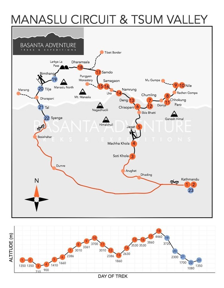
Trip Facts:
Trek Name : Manaslu circuit & Tsum Valley Trek
Trek Code: BATE NEP 018
Grade : Strenuous
Max Elevation: 5213m/17103ft
Accommodation : Hotel / Lodge
Meal : Bed & Breakfast in the city & Accommodation only during the trek
Transport : Flight / Private / Public
Trek Days : 18
Total Days : 24
Manaslu Circuit Trek with Tsum Valley Trek
The 24-day Manaslu Circuit Trek with Tsum Valley combines remote Buddhist villages, sacred monasteries, deep river gorges, and the dramatic Larkya La crossing. Follow the Budhi Gandaki into hidden Tsum Valley, visit Mu Gompa, then rejoin the Manaslu Circuit through Samagaon and Samdo before crossing Larkya La to Bimthang. It is a demanding journey through one of Nepal’s quieter Himalayan regions.
Trek Overview
This region is a part of restricted area requiring special permit. This trek passes through spectacular mountain scenery and is culturally diverse. We begin in the lower Budi Gandaki valley, an area inhabited by Gurung farmers, and follow a precipitous trail that dips up and down crossing and re-crossing the Budi Gandaki River. As we gain altitude and cross the main Himalayan range we enter a region of strong Tibetan influence where rice terraces give way to fields of barley and buckwheat. The summits of Manaslu and Himalchuli are never far away. Mani walls mark the start of the climb to the Larkya La, a spectacular pass marked by prayer flags that offers outstanding views of the surrounding peaks. Our descent is via the Marsyangdi Valley where we join the Annapurna Circuit trail to Besisahar.
The Tsum Valley is a sacred Himalayan pilgrimage valley situated in northern Gorkha district of Nepal. Tsum comes from the Tibetan word "Tsombo" which means vivid. The trail heads up the valley of the Budi Gandaki River through wild and unexplored country inhabited mainly by members of the Gurung ethnic groups. Good cup of the local cultivated natural coffee and Tatopani hot springs will help you to relax on this intensive trial.
Upper Tsum valley (part of the Inner Himalaya) opens from Chhokung Paro, where hospitable local people (Tibetan group "Tsombo") welcome you with traditional Tibetan Chiya (butter tea) and local meal. The Tsum Valley is extremely rich in cultural assets. The valley is dotted with Gompa (Buddhist monasteries), chorten and Mani walls. The longest Mani walls (over 250m) are at Dzong and Phurpe. The valley preserves steps of the great Buddhist Yogi Chyuchin Milarepa and story about Guru Padmasambhava circumbulation. The people here never slaughter animals, even as sacrifice to the gods. The Tsum Valley is surrounded by the Buddha Himal and Himal Chuli to the west, Ganesh Himal to the south, and Sringi Himal to the North.
Tsum valley is stretched along the Syar Khola. Its lower part joins the Budi Gandaki Valley north of Philim. Its upper part reaches north towards the Nepal-Tibet border. The 4000 people inhabiting the valley belong to an indigenous ethnic group known as “Tsumbas”. They maintain a Tibetan – Buddhist way of life, and due to the geographical characteristics of the area, their bonds with Tibet are in some aspects stronger than with Nepal. The Tsum Welfare Committee (‘TWC”) is an NGO which was founded in order to promote the welfare interests of Tsum Valley people. Part of its activities is to promote tourism to the area and assisting visitors arrange treks to this area.
Trek begins with warm traditional welcome and quick safety briefing followed by comprehensive trip briefing next day, introduction to your guide and entertain last minutes questions.
Experience Manaslu and Tsum Valley with Basanta Adventure
Travel Deeper. Experience More. Journey with Purpose.
The Manaslu Circuit with Tsum Valley is more than a high-altitude trek. It is a journey through secluded Buddhist communities, ancient monasteries, deep river gorges, alpine landscapes and some of Nepal’s quieter mountain trails.
Since 1998, Basanta Adventure has organised Himalayan journeys throughout Nepal and the wider region. Our experienced local team manages the additional coordination required for this route, including restricted-area permits, road transport, accommodation, guides, porter support and changing trail conditions.
We also believe that travelling through culturally sensitive mountain communities should be done responsibly. We encourage respect for monasteries, villages and local traditions while supporting local lodges, trekking staff and community services wherever possible.
If you are looking for a demanding Himalayan journey that combines remote culture, quieter trails and the challenge of crossing Larkya La, the Manaslu Circuit with Tsum Valley offers one of Nepal’s most complete long-distance trekking experiences.
Start planning your Manaslu Circuit Trek with Tsum Valley with Basanta Adventure.
What is included in the tour
Kathmandu Portion:
- 3 nights in reputed 3 star Hotel on BB basis as per the itinerary in Kathmandu
- Half day guided sightseeing tour of Kathmandu
- 1 professional English speaking guide
- Private transportation during sightseeing
- All entrance fee during sightseeing
Transportation:
- Private vehicle to and from trek initiation point.
- All the necessary airport transfers as per the itinerary
Trek Portion:
- Twin sharing accommodation on EP ( room only ) basis as per the itinerary in lodge en-route
- ACAP permit fee
- MCAP permit fee
- TIMS Card
- Manaslu restricted area permit
- Tsum Valley permit
- Professional licensed holder Trekking guide
- Assistant Guides as per number of clients
- Necessary Porters (weight max. 12 kg per clients)
- Insurance for Nepali staffs
- Necessary equipment for trekking staff
- Guide and porter daily allowance
- Emergency medical kit box
- Trekking kit bag
What is NOT included in the tour
- Nepal Visa fee
- Any meals (Breakfast, Lunch, Dinner and Tea/Coffee) during trek
- Travel insurance (must cover expenses of rescue service including helicopter)
- Personal Gears: ( all trekking gears are easily available on rent and buy in Kathmandu)
- Lunch and dinner in Kathmandu.
- Liquor beverages (soft and hard drinks)
- Expenses of personal nature e.g. laundry, phone call etc.
- Gratuity for staff
- Expenses incurred due to unforeseen circumstances
- Services not mentioned herein
- Combine the remote Tsum Valley Trek with the complete Manaslu Circuit in one 24-day journey.
- Explore Chumling, Chhokang Paro, Nile, and Mu Gompa with their Tibetan Buddhist traditions and monasteries.
- Follow the Budhi Gandaki through deep gorges, forests, suspension bridges, and traditional mountain villages.
- Spend an acclimatization day at Samagaon beneath Mount Manaslu.
- Reach Samdo at approximately 3,860m near the historic Nepal-Tibet trade corridor.
- Cross Larkya La at approximately 5,160m, the highest point of the trek.
- Descend through the spectacular glacial valley of Bimthang into forests and lower mountain settlements.
- Experience a strenuous restricted-area trek with quieter trails and strong cultural depth
Day 1Arrival in Kathmandu, Elevation: Approximately 1,300m
+
Arrival in Kathmandu, Elevation: Approximately 1,300m
A Basanta Adventure representative will welcome you at Tribhuvan International Airport and transfer you to your hotel.
The remainder of the day is free to rest and recover from your international journey.
Day 2Trek Briefing and Kathmandu Sightseeing, Elevation: Approximately 1,300m, Activity: Briefing, Permit Preparation and Sightseeing
+
Trek Briefing and Kathmandu Sightseeing, Elevation: Approximately 1,300m, Activity: Briefing, Permit Preparation and Sightseeing
After breakfast, meet your guide for a detailed briefing covering the route, restricted-area rules, permits, altitude, equipment, accommodation, and Larkya La crossing.
Later, enjoy guided sightseeing at selected Kathmandu Valley heritage sites before completing final trek preparations.
Day 3Drive from Kathmandu to Soti Khola, Elevation: Approximately 710m, Duration: Approximately 8 to 9 hours
+
Drive from Kathmandu to Soti Khola, Elevation: Approximately 710m, Duration: Approximately 8 to 9 hours
We drive west from Kathmandu towards Gorkha, Arughat, and the Budhi Gandaki Valley.
The final road sections can be rough and travel time varies with current road conditions. Upon reaching Soti Khola or the confirmed roadhead, we settle into a local lodge.
Day 4Trek from Soti Khola to Machha Khola, Elevation: Approximately 900m, Distance: Approximately 14 to 15 km, Duration: Approximately 6 to 7 hours
+
Trek from Soti Khola to Machha Khola, Elevation: Approximately 900m, Distance: Approximately 14 to 15 km, Duration: Approximately 6 to 7 hours
The country changes, the broad valley narrows and at times the trail is cut into the steep valley side which is densely forested. We pass a number of small villages tucked into the hillside, until we reach a widening of the valley, opposite the point where a large tributary stream enters the Budi Gandaki.
The terraced farmland here belongs to the village of Lapbesi. We descend once again to the wide, sandy riverbed and follow a path, which runs below the steep, craggy valley side. At length, we have to climb up once again on a trail to Machha Khola, which has a number of teashops. O/N at Lodge in Machha Khola (EP)
Day 5Trek from Machha Khola to Jagat, Elevation: Approximately 1,340 to 1,410m, Distance: Approximately 20 to 22 km, Duration: Approximately 6 to 7 hours
+
Trek from Machha Khola to Jagat, Elevation: Approximately 1,340 to 1,410m, Distance: Approximately 20 to 22 km, Duration: Approximately 6 to 7 hours
We cross the Machha Khola - Fish Stream - and head upstream to the tiny village of Khola Besi and the hot springs at Tatopani. The valley becomes steeper until they are impassable and the route then switches to the left bank by way of a suspension bridge.
The trail is quite exposed and challenging in places. After a short section of forest path we reach the single teahouse at Doban. Above Doban, the Budi Gandaki descends an impressive series of rapids. Beyond this steep section, the river is much more placid, meandering across a broad gravel bed. At Lauri, we will cross the river on a suspension bridge, and then climb on a high path to the fields of Jagat. O/N at Lodge in Jagat (EP)
Day 6Trek from Jagat to Chisopani, Elevation: Approximately 1,660m, Distance: Approximately 7 to 9 km, Duration: Approximately 4 to 5 hours
+
Trek from Jagat to Chisopani, Elevation: Approximately 1,660m, Distance: Approximately 7 to 9 km, Duration: Approximately 4 to 5 hours
After completing with the ACAP procedure, we climb over a rocky ridge to Salleri, and then descend to Sirdibas. The valley widens a bit as the trail continues up to Ghatta Khola. Continue upstream to a long simple hanging bridge. Climb up to Philim, a large gurung village.
Philim valley is well known for Japanese made school and police station. Walk past Philim to the north across a forest with the views of the narrowing valley we reach Chisopani. O/N at Lodge in Chisopani (EP
Day 7Trek from Chisopani to Chumling, Elevation: Approximately 2,386m, Distance: Approximately 8 to 9 km, Duration: Approximately 6 to 7 hours
+
Trek from Chisopani to Chumling, Elevation: Approximately 2,386m, Distance: Approximately 8 to 9 km, Duration: Approximately 6 to 7 hours
After Ekle Bhatti cross the gorge and half an hour walk in the right side we get to see the big and beautiful waterfall and enter the pine tree forests. Descend down to trail going to the Tsum Valley. Climb through pine and rhododendron forests. Enjoy the views of Himalchuli Mountains at 7893m and Boudha Himal from Lokpa, a small beautiful village.
Pass Lokpa, descend half an hour towards Lungwa khola and climbing jick jack difficult trail further two hours north through pines and rhododendrons we reach Gumlung. Crossing the Siyar Khola, finally arrive at Chumling, from where we can view Shringi Himal. Visit the old Chumling gompa, and the stone streets of the village. O/N at Lodge in Chumling (EP
Day 8Trek from Chumling to Chhokang Paro, Elevation: Approximately 3,010m, Distance: Approximately 7 to 8 km, Duration: Approximately 4 to 5 hours
+
Trek from Chumling to Chhokang Paro, Elevation: Approximately 3,010m, Distance: Approximately 7 to 8 km, Duration: Approximately 4 to 5 hours
Cross the suspension bridge onto the opposite bank. Enjoy the great views of Ganesh Himal. Walk past Rainjam to Serpu Khola crossing another bridge we arrive at the Gho Village.
Another continues 2 hours climb to Tsum takes us to the village of Chhokangparo. Weather permitting; enjoy the views of Himalchuli at 7893 meters and Ganesh Himal at7140m. O/N at Lodge in Chhokangparo (EP)
Day 9Trek from Chhokang Paro to Nile, Elevation: Approximately 3,361m, Distance: Approximately 9 to 11 km, Duration: Approximately 5 to 6 hours
+
Trek from Chhokang Paro to Nile, Elevation: Approximately 3,361m, Distance: Approximately 9 to 11 km, Duration: Approximately 5 to 6 hours
While climbing above Chokhangparo, better to be careful of altitude problems. Walk past Lamagaon crossing rope suspension bridge to the Rachen Gompa, which is also well known as Nunnery Gompa too.
We make a small visit and then we cross the Shiar Khola. Continue walking through the well managed villages Lar (micro hydro power), Phurbe and Pangdun. Leaving old historic Stupa of Bhudda in a way crossing the village of Chhule, climb upstream and cross the bridge to finally arrive at Nile. If you consider we can make your visit to a famous monastery of Chhule which is located in the top of area. O/N at Lodge in Nile (EP)
Day 10Excursion to Mu Gompa, Elevation: Approximately 3,700m, Duration: Approximately 6 to 7 hours
+
Excursion to Mu Gompa, Elevation: Approximately 3,700m, Duration: Approximately 6 to 7 hours
We are now almost close to the Tibetan border. Walk to the west bank of the valley through the Tibetan landscapes. Climb up to the Mu Gompa. We also visit the monastery. Then after, we trek back to Nile. O/N at Lodge in Nile (EP)
Day 11Trek from Nile to Chhokang Paro, Elevation: Approximately 3,010m, Duration: Approximately 6 hours
+
Trek from Nile to Chhokang Paro, Elevation: Approximately 3,010m, Duration: Approximately 6 hours
We retrace the upper Tsum Valley through Chhule, the Rachen Gompa area, villages, farmland, and Buddhist monuments.
The lower elevation makes the walking more comfortable as we return to Chhokang Paro.
Day 12Trek from Chhokang Paro to Chumling, Elevation: Approximately 2,386m, Distance: Approximately 7 to 8 km, Duration: Approximately 5 to 6 hours
+
Trek from Chhokang Paro to Chumling, Elevation: Approximately 2,386m, Distance: Approximately 7 to 8 km, Duration: Approximately 5 to 6 hours
We continue descending through village paths and forested slopes towards lower Tsum Valley.
The evening in Chumling marks our final night before returning to the main Manaslu Circuit.
Day 13Trek from Chumling to Deng, Elevation: Approximately 1,860m, Distance: Approximately 14 to 15 km, Duration: Approximately 6 to 7 hours
+
Trek from Chumling to Deng, Elevation: Approximately 1,860m, Distance: Approximately 14 to 15 km, Duration: Approximately 6 to 7 hours
Leaving Chumling behind, we will trek through subtropical forests, small villages, and rivers. The trail will take us to Salleri and descend the Sirdibas. From here, we will trek and reach Ghatta Khola and continue trekking until we reach a suspension bridge. We will cross the bridge and reach Philim.
Further, trekking in the north, we will reach Ekle Bhatti and descend to a grassy slope. We will then cross Budhi Gandaki River a few times and pass by bamboo forests to reach Deng. O/N at Lodge in Deng (EP)
Day 14Trek from Deng to Namrung, Elevation: Approximately 2,630m, Distance: Approximately 15 to 19 km, Duration: Approximately 6 to 7 hours
+
Trek from Deng to Namrung, Elevation: Approximately 2,630m, Distance: Approximately 15 to 19 km, Duration: Approximately 6 to 7 hours
Today we will again cross Budi Gandaki several times before we reach Namrung. On the way we will have an opportunity of seeing magnificent view of the mountains along with many historical gompas. O/N at Lodge in Namrung (EP)
Day 15Trek from Namrung to Samagaon, Elevation: Approximately 3,530m, Distance: Approximately 17 to 20 km, Duration: Approximately 7 to 8 hours
+
Trek from Namrung to Samagaon, Elevation: Approximately 3,530m, Distance: Approximately 17 to 20 km, Duration: Approximately 7 to 8 hours
Namrung village is a good viewpoint for Siring and Ganesh Himal and from the village one can also see Mt. Himal Chuli in the south. We climb steadily and pass through forests and reach Lihi, a fine village with many chortens and barley terraces. The trail drops and crosses the side valley of Simnang Himal with Ganesh Himal always close by. We further pass through Sho, Lho and Shyala villages before reaching Sama Village.
We enjoy extraordinary views of Mt. Manaslu from Lho village and also explore the famous Ribung Gompa. In Shyala village we will be surrounded by high mountains like Himal Chuli and Peak 29 (Ngadi Chuli) to the left, Manaslu and large glaciers straight ahead, and other snow summits to the right, and at the far end stands Ganesh Himal. Today’s journey ends in Samagaon where we spend the night. O/N at Lodge in Samagaon (EP)
Day 16Acclimatization Day at Samagaon, Elevation: Approximately 3,530m, Activity: Acclimatization and Exploration Hike
+
Acclimatization Day at Samagaon, Elevation: Approximately 3,530m, Activity: Acclimatization and Exploration Hike
We spend the day at Samagaon both for rest and acclimatization. Today, we get acquainted with the rich Sherpa culture. We enjoy the sight of thousands of mani stones with Buddhist texts and pictures and the Sherpa women clad in traditional clothes and ornaments.
On a little hill near the Sama village is an old Gompa (Pungyen Gompa), a monastery with great views of the glacier. It is named after Manaslu; Pungyen means bracelet, a good description of the two peaks. It was destroyed a year after the first unsuccessful Japanese attempt to climb Manaslu. The locals believed that the climb angered the gods, and when the Japanese came back a year later they met with a lot of resistance that they had to give up their attempt. They were finally successful in 1959. O/N at Lodge in Samgon (EP
Day 17Trek from Samagaon to Samdo, Elevation: Approximately 3,860m, Distance: Approximately 8 km, Duration: Approximately 4 to 5 hours
+
Trek from Samagaon to Samdo, Elevation: Approximately 3,860m, Distance: Approximately 8 km, Duration: Approximately 4 to 5 hours
After breakfast in Samagaon, we'll descend to the Budhi Gandaki River and follow it to a bridge over a side stream. We’ll pass several mani walls as the valley begins to widen.
The mountain views along this route are amazing and get you close to the Tibetan border. This is an easy trek on a shelf above the river that passes juniper and birch forests in Kermo Kharka. Drop down and cross the Budhi Gandaki on a wooden bridge, and then climb steeply onto a promontory between two forks of the river. We'll come to a stone archway and continue walking until we find the village of Samdo. O/N at Lodge in Samdo (EP)
Day 18Trek from Samdo to Dharamsala, Elevation: Approximately 4,460m, Distance: Approximately 10 to 12 km, Duration: Approximately 4 to 5 hours
+
Trek from Samdo to Dharamsala, Elevation: Approximately 4,460m, Distance: Approximately 10 to 12 km, Duration: Approximately 4 to 5 hours
After breakfast in Samdo, we'll pass a seasonal Tibetan market called Larke Bazaar and descend to the Budi Gandaki River. Cross the wooden bridge and begin walking upward, crossing two streams while witnessing the Larkya Glacier.
We’ll head around the valley of the Salka Khola and climb up again to Dharamsala, also known as Larke Phedi. Along the route, we'll see many traditional monasteries. O/N at Lodge in Dharmasala (EP)
Day 19Cross Larkya La and Trek to Bimthang, Larkya La: Approximately 5,160m, Bimthang Elevation: Approximately 3,720m, Distance: Approximately 15 to 20 km, Duration: Approximately 8 to 9 hours
+
Cross Larkya La and Trek to Bimthang, Larkya La: Approximately 5,160m, Bimthang Elevation: Approximately 3,720m, Distance: Approximately 15 to 20 km, Duration: Approximately 8 to 9 hours
After a short climb, we reach a valley on the north side of the Larkya Glaciers from where we can enjoy great views of Cho Danda and Larkya Peak. Finally, we walk across moraines of the glacier, making a gradual ascent which becomes steeper only in the last section of the pass.
From the pass, there are outstanding views of Himlung Himal, Cheo Himal, Kangguru and the huge Annapurna II. It is a longer day than usual to Bimtang, but to walk into these low pastures with the evening mist coming in with Mt. Manaslu looming close by is an overwhelming experience. Your guide will organise a prayer and offer Lungta (Prayer flag) for good health and happiness for all the members. O/N at Lodge in Bimthang (EP)
Note: Offer Lungta or prayers flag (printed prayers for the peace and good health/happiness) together with our Guide. Offering prayer flag in high passes and sacred sites is believed to bring good fortune and long life in Buddhist culture
Day 20Trek from Bimthang to Tilije, Elevation: Approximately 2,300m, Distance: Approximately 13 to 16 km, Duration: Approximately 5 to 6 hours
+
Trek from Bimthang to Tilije, Elevation: Approximately 2,300m, Distance: Approximately 13 to 16 km, Duration: Approximately 5 to 6 hours
After breakfast in Bimthang, head out to a nearby ridge where we can enjoy great views of Manaslu, Lamjung Himal, Himlung Himal, and Cheo Himal. Keep descending on the trail and cross a high pasture followed by a bridge over the Dudh Khola River. From here, walk through a rhododendron forest and follow a trail through a narrow valley until we reach the highest cultivated land of the valley at Karche.
Pass through lush fields before making a steep climb over a ridge. The trail comes off the ridge in a big, sweeping arc to the river bank. A short distance beyond is the village of Gho where some trekkers choose to stay the night, but we'll continue walking until we get to Tilije. O/N at Lodge in Tilije (EP)
Day 21Trek from Tilije to Tal, Elevation: Approximately 1,700m, Distance: Approximately 12 km, Duration: Approximately 5 to 6 hours
+
Trek from Tilije to Tal, Elevation: Approximately 1,700m, Distance: Approximately 12 km, Duration: Approximately 5 to 6 hours
We climb over a small ridge and enjoy the stone paved trail as it passes through a beautiful village. We then cross the bridge over Dudh Khola and climb up through a chorten-shaped arch, pass a Mani wall and reach the Thonje village. At the village, we go through a police checkpoint and continue to Dharapani.
We have entered the Annapurna circuit section from Dharapani. Further down, we come across Karte village and after quite a bit of walking we cross a bridge over Marshyangdi Khola. We also come across some Mani walls before reaching the village of Tal, situated at the foot of a large waterfall. O/N at Lodge in Take (EP)
Day 22Trek from Tal to Syange, Elevation: Approximately 1,080m, Distance: Approximately 15 to 18 km, Duration: Approximately 6 to 7 hours
+
Trek from Tal to Syange, Elevation: Approximately 1,080m, Distance: Approximately 15 to 18 km, Duration: Approximately 6 to 7 hours
After breakfast in Tal, we’ll follow the trail down a sometimes steep trail to the village of Chyamje crossing the beautiful Marsyangdi Khola (once again) via a suspension bridge. The valley of the same name opens with its terrace fields while villages clung very high to the hillsides.
The trail then descends further through picturesque rhododendron and pine forests to get to the village of Syange where we'll stay the night. This will be our last night with your trekking crew except trekking Guide, this is best time to tip the staff (not compulsory but it’s a customary), an impromptus little ceremony and always enormous Sherpa smiles. Then something of a party is inevitable. Try local drink called “Rakshi”, please be aware; it does not taste good and is very strong. O/N at Lode in Syange (EP)
Day 23Drive from Syange to Kathmandu, Distance: Approximately 180 to 200 km, Duration: Approximately 8 to 9 hours
+
Drive from Syange to Kathmandu, Distance: Approximately 180 to 200 km, Duration: Approximately 8 to 9 hours
Wake up with breakfast in Syange and perhaps take one last walk around the village before you hit the road.
The drive from to Kathmandu via Besi Sahar offers an opportunity to enjoy both hill and mountain landscapes often coming into direct view with the banks of the Marsyangdi and Trishuli rivers. We'll also drive by some beautiful villages with farming terraces on both sides of the road. O/N Hotel in Kathmandu (BB)
Day 24Holiday extension or transfer to airport for final departure:
+
Holiday extension or transfer to airport for final departure:
Your 24-day Manaslu Circuit Trek with Tsum Valley Trek comes to an end today. According to your international flight schedule, a Basanta Adventure representative will transfer you to Tribhuvan International Airport.
During the journey, you will have followed the Budhi Gandaki into secluded Tsum Valley, visited Mu Gompa, trekked beneath Manaslu through Samagaon and Samdo, crossed Larkya La at approximately 5,160m, and descended through Bimthang into the Marsyangdi Valley.
For trekkers seeking remote culture, high-altitude adventure, and quieter Himalayan trails, this combination offers one of Nepal’s most complete long-distance trekking journeys.